Cycling the New Territories Border Skirmish
Surely riding long in the NT does not HAVE to mean riding those nasty truck-filled sections nestled in between those golden nuggets of tarmac? Last year I decided to spend valued time and committed effort to devise a route, or collection of routes, that minimised the stretches of town-planning hell and maximized those moments of “Are we really still in Hong Kong???”. And, apart from the obvious success of having to ride my bike to do this research, I have been rewarded by the discovery of many hidden little bypasses and quiet side-roads.
So, over the next few weeks, I plan to share several great options for cycling in the New Territories ranging from fairly simple well-known routes to some very unknown gems that are begging to be explored further. This one is the "Border Skirmish" as it skirts the West and Northern borders where some of the quietest roads can be found.

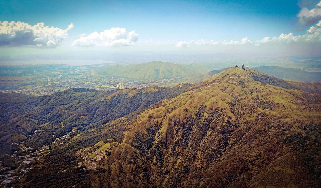
Starting from Kam Sheung Rd, the ride consists of a gentle warm-up towards Tai Mo Shan before starting the climb over Route Twisk which is pretty much the only climb of the ride. Route TWISK was built by the British Army in the 1940's and its name came from a misprint in a construction project document (Route TW/SK meaning Tsuen Wan to Shek Kong). However, I always thought it was a good play on the word "Twist" because straight it ain't. At the start of the climb, you'll notice the PLA soldiers guarding all the Chinese Army buildings, which were British Army until 1997. Be aware that there are often speeding motorbikes on this curvy piece of tarmac, particularly on Sunday or Public Holiday mornings, so if that makes you nervous then a good option is to tackle it very early. The motorbikes can be there at any time but apart from that, the road up the TWISK is generally fairly quiet and scenic. Once you've made the 400m vertical ascent to the top of TWISK, it's time to descend, or....consider a little out and back extension up to the top.
Optional Extension to the top
It might seem a tad early talking about extensions when you've only covered the first 10km, but the Border Skirmish route does not include the full climb up Tai Mo Shan, so this is an optional extra for those with a solid climbone. So if you do want to tackle the extra 400 challenging vertical metres then make sure you turn left into the country park road before you start the descent towards Tsuen Wan. It's a tough but rewarding climb to the top.
Can't decide if the extra climb is for you? Well just LOOK AT IT!!
Tuen Muen is the Armpit
Castle Peak Rd is a real gem of a road for cyclists, 2 lanes in both directions and very little traffic, so its great for training, and you'll see Triathletes in aero doing their laps. It has a real Zwift feel to it (see image), can feel very surreal sometimes, the sort of classic combination of mountain, road and sea.
The main problem with Castle Peak Rd is that it leads you to Tuen Muen, a "new town" jammed with traffic lights and annoyances. I've yet to find a viable alternative to avoid the 5km of stop-starts (probably 10 traffic lights). There are some gold nuggets in the area, and I'll cover them in another blog, but for this ride, we are just passing through. Just take it easy, have some catch-up chit-chat at the lights and it'll soon be behind you on you're on your way to the border fence road which is a highlight.

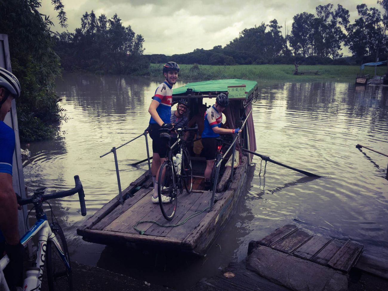
Nam Sang Wai Ferry
Nam Sang Wai is an important wetland area for migratory birds but recently its been subject to all sorts of dodgy developer activity including the deliberate setting of fires, 4 in the first part of 2018! This tactic of damaging ecologically important areas so that they can be rezoned for development has been common in Hong Kong for years, and we can only hope that environmentalists keep up their work to protect the site!
Once through a maze of industrial buildings and then down a small and unremarkable path, you'll suddenly come across the Nam Sang Wai Ferry, Hong Kong's last river ferry. This has to be about as quirky as you can get in Hong Kong, jumping on a tiny sampan to cross a 30m wide river that you certainly would never swim in! Up to 6 bikes and riders can hop on to the sampan for the oar-powered crossing that costs $6 per person and $1 for a bike. On the other side of the ferry, it easy to miss the Dai Pai Don around the corner to the right, elevated above a fishpond on stilts, and a great spot to get a drink and some mid-ride noodles.
Northern Border Road
A 710-hectare restricted zone, a bulwark between Hong Kong and Mainland China was established in 1951 amid political tension when many mainlanders fled to Hong Kong. Tourists used to walk up to the lookout at Lok Ma Chau and peer across over the forbidden area, Hong Kong's own DMZ, to peek at the communists. In 2013 the government opened up to the area of fields and fishponds to the public which is fantastic news for cyclists as it features a great road that is another highlight of this loop.
You'll be relieved to arrive here and get away from the trucks and buses near the border control point. Although I did promise to remove all the shit sections from my routes, I am not a miracle worker, and unfortunately cannot exclude a nasty 4km stretch of Castle Peak Rd (yes Castle Peak Rd again!) to Lok Ma Chau. Its broken tarmac is sometimes busy with trucks unless you are smart enough to hit it midday on a Sunday / Public Holiday when it is very quiet indeed. Nevertheless, you will be WELL rewarded with the border road!

Fan Kam Rd and Kam Tin
Conveniently there is a nice quiet little connecting road that joins the North Border Rd with Fan Kam Rd, which means you can totally bypass Sheung Shui and those nasty dual carriageway roundabouts. Fan Kam Rd is a great piece of rolling road, starting with a nicely shaded screen of trees that border the Fanling Golf Club, and only blighted by being a little narrow for the impatient minibus drivers and occasionally a touch busier than you'd like. Its a good stretch of undulations that creeps into a draggy climb before dropping towards Pat Heung. Make sure you keep an eye on your GPS and take the right turn off it onto the Kam Tin canals for a nice peaceful finale to the ride.
Once off Fan Kam Rd, you'll be on the Yuen Long Plain, the largest alluvial plain in Hong Kong. I remember massive floods here in the 90's and soon after the Government built over-sized drainage nullas but thoughtfully put some quiet roads alongside them. These will take you along the Northern edge of Kam Tin and I have added an optional out-and-back to the "Tree House" and a few of the old buildings in the walled village in the area. These are well worth a look but if you are toast then just head straight for the station (hopefully you should be able to differentiate the endpoint of the ride from an out and back on your GPS).
That's the Border Skirmish in a nutshell, I hope you enjoy it!